waterPML --Nx=101 --Nz=51 --Npmx=10 --x0=-505.0 --y0=-505.0 --z0=-400.0 --dx=10.0 --dt=0.001 --tmax=10.0 --structure_file=structure.ini --structure_file_format=layer --source_file=source3.ini --output_dir=result03 --station_file=station_list3.dat --topography_files=topography_constant_slope.dat --topography_file_format=xy |
-600.0[TAB]-600.0[TAB]-100.0 -600.0[TAB]600.0[TAB]-100.0 600.0[TAB]-600.0[TAB]100.0 600.0[TAB]600.0[TAB]100.0 |
newsource isotropic location_x=0.0 location_y=0.0 location_z=-195.0 mechanism=isotropic intensity=1.0 stfun_name=pow5 stfun_tp=5.0 |
y0_x-500[TAB]-500.0[TAB]0.0[TAB]surface-0.1 y0_x-490[TAB]-490.0[TAB]0.0[TAB]surface-0.1 y0_x-480[TAB]-480.0[TAB]0.0[TAB]surface-0.1 … y0_x500[TAB]500.0[TAB]0.0[TAB]surface-0.1 y200_x-500[TAB]-500.0[TAB]200.0[TAB]surface-0.1 y200_x-490[TAB]-490.0[TAB]200.0[TAB]surface-0.1 y200_x-480[TAB]-480.0[TAB]200.0[TAB]surface-0.1 … y200_x500[TAB]500.0[TAB]200.0[TAB]surface-0.1 |
rm -f station_list3.dat for((x=-500;x<=500;x+=10)) do /bin/echo -e "y0_x${x}\t${x}.0\t0.0\tsurface-0.1" >> station_list3.dat done for((x=-500;x<=500;x+=10)) do /bin/echo -e "y200_x${x}\t${x}.0\t200.0\tsurface-0.1" >> station_list3.dat done |
cd result03/waveform for inputfile in *.Tx.seq1 *.Ty.seq1 do outputfile=`echo $inputfile | sed "s/.seq1/.int.seq1/"` sequencefile_integral $inputfile $outputfile done |
for((x=-480;x<=480;x+=10)) do ((xm2=x-20)) ((xm1=x-10)) ((xp1=x+10)) ((xp2=x+20)) file1=y0_x${xm2}.Tx.int.seq1 file2=y0_x${xm1}.Tx.int.seq1 file3=y0_x${x}.Tx.int.seq1 file4=y0_x${xp1}.Tx.int.seq1 file5=y0_x${xp2}.Tx.int.seq1 sequencefiles_average --inputfiles=$file1,$file2,$file3,$file4,$file5 --outputfile=y0_x${x}.Tx.int.ave5.seq1 done |
rm -f permanent_tilt.dat for((x=-480;x<=480;x+=10)) do tilt1=`tail -n 1 y0_x${x}.Tx.int.seq1` tilt5=`tail -n 1 y0_x${x}.Tx.int.ave5.seq1` /bin/echo -e "$x\t$tilt1\t$tilt5" >> permanent_tilt.dat done cd ../.. |
source_amplitude=`echo 2500.0 2000.0 |
awk '{ mu=$1*$2*$2/3.0;
printf("%e",1.0/(4.0*3.1415926*mu)) }'` Mogi --source_location=0.0,0.0,-195.0 --source_amplitude=$source_amplitude --station_list_file=station_list3.dat --z0=0.0 --slope_x=9.46 --outputfile=result03_check/analytical_solution.dat |
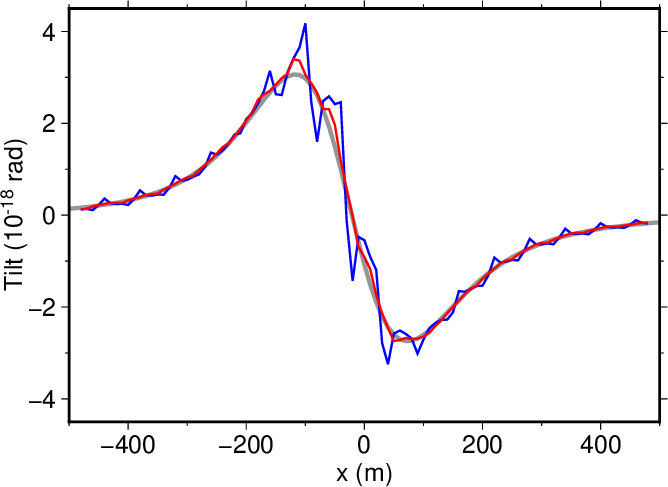
mkdir result03_tilt_comparison cd result03_tilt_comparison gmt begin comparison ps gmt set FONT_ANNOT_PRIMARY 12p grep y0_ ../result03_check/analytical_solution.dat | awk '{ print $7,$5*1e+18 }' | gmt plot -R-500/500/-4.5/4.5 -JX10/7 -Xa3 -Ya3 -W2,150/150/150 awk '{ print $1,$2*1e+18 }' ../result03/waveform/permanent_tilt.dat | gmt plot -R-500/500/-4.5/4.5 -JX10/7 -Xa3 -Ya3 -W1,0/0/255 awk '{ print $1,$3*1e+18 }' ../result03/waveform/permanent_tilt.dat | gmt plot -R-500/500/-4.5/4.5 -JX10/7 -Xa3 -Ya3 -W1,255/0/0 -Bxa200f100 -Bya2f1 -BWSen gmt text -R0/21/0/29.7 -JX21/29.7 -Xa0 -Ya0 -F+f12p+a+j <<EOF 8.0 2.3 0 CT x (m) 2.2 6.5 90 CB Tilt (10@+-18@+ rad) EOF gmt end |
図1. \(y=0\)の断面における傾斜変動の\(x\)成分。 灰色は茂木モデルに基づく解析解、 青はwaterPMLコマンドによる数値解である。 数値解を隣接する5つの格子セルで平均した結果を赤で示す。 Fig. 1. The \(x\)-component of tilt along a transect of \(y=0\). Gray and blue lines show an analytical solution from the Mogi model and a numerical solution from the waterPML command, respectively. The red line show the numerical solution averaged over adjacent five grid cells. |