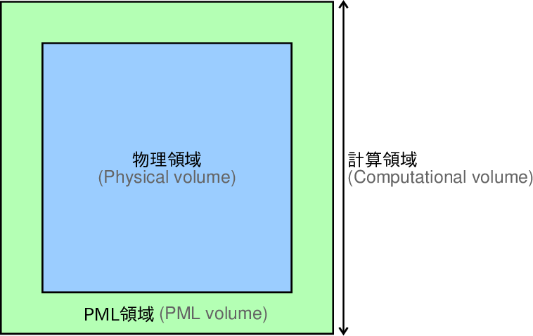
図1. 物理領域、PML領域、計算領域の関係。
Fig. 1. Relations of physical, PML, and computational volumes.
|
図1. 物理領域、PML領域、計算領域の関係。 Fig. 1. Relations of physical, PML, and computational volumes. |
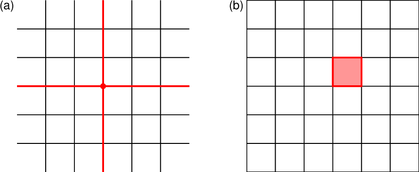 図2. (a)格子点と(b)格子セルの捉え方。このプログラムでは(b)の考え方を取る。 Fig. 2. Schematic illustrations of (a) a grid node and (b) a grid cell. This program uses the concept of (b). |
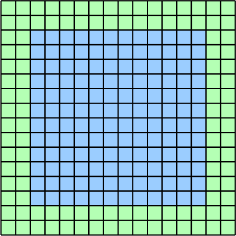 図3. 格子セルと物理領域、PML領域の関係。領域の塗りつぶし色は図1と同じ。 Fig. 3. Relation between grid cells and the physical and PML volumes. The fill colors for the volumes are consistent with those of Fig. 1. |
| パラメータ名 Parameter name |
意味 Meaning |
可能なパラメータ値 Allowed parameter values |
デフォルト値 Default value |
| Nx | 物理領域内の\(x\)方向の格子セルの数(\(N_x\))。 The number of grid cells along the \(x\)-direction in the physical volume (\(N_x\)). |
3以上の整数。 An integer greater than or equal to 3. |
省略不可 Cannot be omitted |
| Ny | 物理領域内の\(y\)方向の格子セルの数(\(N_y\))。 The number of grid cells along the \(y\)-direction in the physical volume (\(N_y\)). |
3以上の整数。 An integer greater than or equal to 3. |
\(N_x\) |
| Nz | 物理領域内の\(z\)方向の格子セルの数(\(N_z\))。 The number of grid cells along the \(z\)-direction in the physical volume (\(N_z\)). |
3以上の整数。 An integer greater than or equal to 3. |
\(N_x\) |
| Npmx | \(x\)軸の\(-\)側のPML領域の格子セルの数(\(N_{pml}^{-x}\))。 The number of grid cells in the PML volume on the negative side of the \(x\)-axis (\(N_{pml}^{-x}\)). |
1以上の整数。 An integer greater than or equal to 1. |
省略不可 Cannot be omitted |
| Npmy | \(y\)軸の\(-\)側のPML領域の格子セルの数(\(N_{pml}^{-y}\))。 The number of grid cells in the PML volume on the negative side of the \(y\)-axis (\(N_{pml}^{-y}\)). |
1以上の整数。 An integer greater than or equal to 1. |
\(N_{pml}^{-x}\) |
| Npmz | \(z\)軸の\(-\)側のPML領域の格子セルの数(\(N_{pml}^{-z}\))。 The number of grid cells in the PML volume on the negative side of the \(z\)-axis (\(N_{pml}^{-z}\)). |
1以上の整数。 An integer greater than or equal to 1. |
\(N_{pml}^{-x}\) |
| Nppx | \(x\)軸の\(+\)側のPML領域の格子セルの数(\(N_{pml}^{+x}\))。 The number of grid cells in the PML volume on the positive side of the \(x\)-axis (\(N_{pml}^{+x}\)). |
1以上の整数。 An integer greater than or equal to 1. |
\(N_{pml}^{-x}\) |
| Nppy | \(y\)軸の\(+\)側のPML領域の格子セルの数(\(N_{pml}^{+y}\))。 The number of grid cells in the PML volume on the positive side of the \(y\)-axis (\(N_{pml}^{+y}\)). |
1以上の整数。 An integer greater than or equal to 1. |
\(N_{pml}^{-y}\) |
| Nppz | \(z\)軸の\(+\)側のPML領域の格子セルの数(\(N_{pml}^{+z}\))。 The number of grid cells in the PML volume on the positive side of the \(z\)-axis (\(N_{pml}^{+z}\)). |
1以上の整数。 An integer greater than or equal to 1. |
\(N_{pml}^{-z}\) |
| x0 | 物理領域の\(x\)座標範囲の下端(\(x_0\))。[m] The lower limit of the \(x\)-coordinate range of the physical volume (\(x_0\)). [m] |
任意の実数。 An arbitrary real number. |
0.0 |
| y0 | 物理領域の\(y\)座標範囲の下端(\(y_0\))。[m] The lower limit of the \(y\)-coordinate range of the physical volume (\(y_0\)). [m] |
任意の実数。 An arbitrary real number. |
0.0 |
| z0 | 物理領域の\(z\)座標範囲の下端(\(z_0\))。[m] The lower limit of the \(z\)-coordinate range of the physical volume (\(z_0\)). [m] |
任意の実数。 An arbitrary real number. |
0.0 |
| dx | 格子セルの\(x\)軸方向のサイズ(\(\Delta x\))。[m] The size of grid cells along the \(x\)-direction (\(\Delta x\)). [m] |
0.001以上の実数。 A real number greater than or equal to 0.001. |
省略不可 Cannot be omitted |
| dy | 格子セルの\(y\)軸方向のサイズ(\(\Delta y\))。[m] The size of grid cells along the \(y\)-direction (\(\Delta y\)). [m] |
0.001以上の実数。 A real number greater than or equal to 0.001. |
\(\Delta x\) |
| dz | 格子セルの\(z\)軸方向のサイズ(\(\Delta z\))。[m] The size of grid cells along the \(z\)-direction (\(\Delta z\)). [m] |
0.001以上の実数。 A real number greater than or equal to 0.001. |
\(\Delta x\) |
| パラメータ名 Parameter name |
意味 Meaning |
可能なパラメータ値 Allowed parameter values |
デフォルト値 Default value |
| dt | 計算の時間刻み(\(\Delta t\))。[s] The time stepping of the computation (\(\Delta t\)). [s] |
\(1.0\times 10^{-6}\)以上の実数。 A real number greater than or equal to \(1.0\times 10^{-6}\). |
省略不可 Cannot be omitted |
| tmin | 計算の先頭時刻(\(t_{min}\))。[s] The beginning time of the computation (\(t_{min}\)). [s] |
\(\Delta t\)に非負の整数を掛けて得られる実数。 A real number that is a non-negative integer multiple of \(\Delta t\). |
0.0 |
| tmax | 計算の末尾時刻(\(t_{max}\))。[s] The end time of the computation (\(t_{max}\)). [s] |
\(\Delta t\)に正の整数を掛けて得られる実数(\(>t_{min}\))。 A real number that is a positive integer multiple of \(\Delta t\) and greater than \(t_{min}\). |
省略不可 Cannot be omitted |
| パラメータ名 Parameter name |
意味 Meaning |
可能なパラメータ値 Allowed parameter values |
デフォルト値 Default value |
| PML_A | (\ref{eq.alpha_k})式の\(A\)の値。 The value of \(A\) in Eq. (\ref{eq.alpha_k}). |
0.0以上の実数。 A real number greater than or equal to 0.0. | 10.0 |
| PML_n | (\ref{eq.alpha_k})式の\(n\)の値。 The value of \(n\) in Eq. (\ref{eq.alpha_k}). |
0.0以上の実数。 A real number greater than or equal to 0.0. | 2.0 |
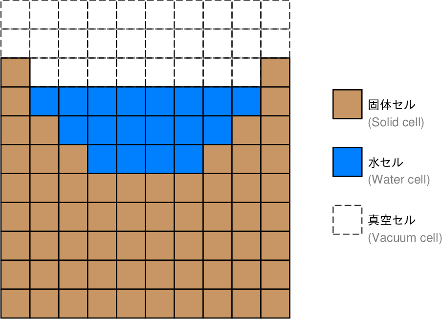 図4. waterPMLコマンドにおける地形と水域の表現方法の模式図。 Fig. 4. Schematic illustration for the representations of the topography and water-filled regions in waterPML command. |
| パラメータ名 Parameter name |
意味 Meaning |
可能なパラメータ値 Allowed parameter values |
デフォルト値 Default value |
| topography_files | 使用する地形データファイル名のリスト。 List of the file names of topography data used. |
ファイル名をカンマ(,)で区切って書き並べた文字列。 A string composed of file names separated by commas (,). |
省略時は地表面無し(無限媒質)での計算となる。 When this parameter is omitted, the computation is performed without the ground surface (i.e., an infinite medium). |
| topography_file_format | 地形データファイルの書式。 The format of the topography data files. |
|
3D |
| refN | 緯度経度で与えられた標高データを直交座標に変換するための
基準点(直交座標系の原点)の緯度。 The latitude of the reference point (the origin of a cartesian coordinate system) to convert the topography data, given in latitudes and longitudes, to the cartesian coordinates. |
「度」単位の実数、または「度:分:秒」表記(度・分は整数)。 A real number in the degree unit, or a “degree:minute:second” representation in which the degree and minute are integers. |
topography_file_format=latlonの場合は省略不可。
その他の場合は使用されない。 Cannot be omitted if topography_file_format=latlon; in the other cases, this parameter is not used. |
| refE | 緯度経度で与えられた標高データを直交座標に変換するための
基準点(直交座標系の原点)の経度。 The longitude of the reference point (the origin of a cartesian coordinate system) to convert the topography data, given in latitudes and longitudes, to the cartesian coordinates. |
「度」単位の実数、または「度:分:秒」表記(度・分は整数)。 A real number in the degree unit, or a “degree:minute:second” representation in which the degree and minute are integers. |
topography_file_format=latlonの場合は省略不可。
その他の場合は使用されない。 Cannot be omitted if topography_file_format=latlon; in the other cases, this parameter is not used. |
| topography_interpolation_method | 地形データの補間に用いる方法。 The method of interpolation of the topography data. |
|
|
| water_file | 使用する水域の設定ファイル名。 The name of the configuration file for water-filled regions used. |
ファイル名。 A file name. ファイルの書式 (File format) |
省略時は水域無しでの計算となる。 When this parameter is omitted, the computation is performed without water-filled regions. |
| パラメータ名 Parameter name |
意味 Meaning |
可能なパラメータ値 Allowed parameter values |
デフォルト値 Default value |
| structure_file | 使用する地下構造の設定ファイル名。 The name of the configuration file for the subsurface structure used. |
ファイル名。 A file name. |
省略不可 Cannot be omitted |
| structure_file_format | 地下構造の設定ファイルの書式。 The format of the configuration file for the subsurface structure. |
|
subdomain |
| パラメータ名 Parameter name |
意味 Meaning |
可能なパラメータ値 Allowed parameter values |
デフォルト値 Default value |
| source_file | 使用する地震波動ソースの設定ファイル名。 The name of the configuration file for the seismic wave source to be used. |
ファイル名。 A file name. ファイルの書式(twsヘッダファイルパッケージ共通) (File format; common to tws header file package) |
省略不可 Cannot be omitted |
| random_seed | 使用する乱数シードの値。
震源時間関数に乱数を用いる場合において、
その震源時間関数生成時の乱数シードとして用いられる。 The value of random seed used for generating source time functions that depend on random values. |
0以上RAND_MAX以下の整数。
RAND_MAXは使用するコンパイラに依存する定数である。 An integer between 0 and RAND_MAX (a constant defined by the compiler used). |
0 |
| source_memory | 地震波動ソースの内部表現の方法。 Internal expression of seismic wave source. |
|
conventional |
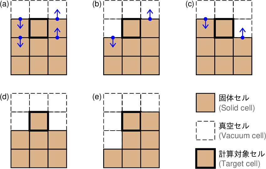 図5. 傾斜変動の計算方法(青矢印)と計算できないケース。 Fig. 5. Computation method for tilt changes (blue arrows) and uncomputable cases. |
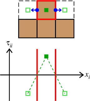 図6. 速度の水平成分が0になるケースとその理由。 地形・水域の表現方法と媒質境界での境界条件参照。 Fig. 6. Cases where a horizontal velocity component is zero and its reason. See The representation methods for the topography and water-filled regions and the conditions on material boundaries. |
| パラメータ名 Parameter name |
意味 Meaning |
可能なパラメータ値 Allowed parameter values |
デフォルト値 Default value |
| output_dir | 計算結果の出力先ディレクトリ名。 The output directory name. |
ディレクトリ名。
既に存在するディレクトリ名を指定した場合には上書きされるので注意。 A directory name. Note that specifying an existing directory results in overwriting it. |
. |
| 波形の出力に関するパラメータ (Parameters for the output waveforms) | |||
| station_file | 波形を出力する地点(観測点)
のリストファイル名。 The name of a file that lists the locations where the waveforms are to be included in the outputs (stations). |
ファイル名。 A file name. ファイルの書式 (File format) |
省略時は波形を出力しない。 When this parameter is omitted, waveforms are not included in the outputs. |
| output_dt | 出力する波形の時間刻み(\(\Delta t_{waveform}\))。
このパラメータを指定することで
計算の時間刻み\(\Delta t\)よりも粗いサンプルで出力することができる。
但し単純に間引くだけであり、
アンチエイリアスフィルターは適用されないことに留意。 The sampling interval of the output waveforms (\(\Delta t_{waveform}\)). By specifying this parameter, the time stepping the output waveforms can be more sparse than that of the computation \(\Delta t\). However, note that the data samples are simply decimated without anti-alias filters. |
\(\Delta t\)の自然数倍。 A natural number multiple of \(\Delta t\). |
\(\Delta t\) |
| スナップショットの出力に関するパラメータ (Parameters for the output snapshots) | |||
| snapshot_grid | スナップショットを出力する空間範囲。 The spatial extent of the output snapshots. |
|
none |
| snapshot_place | スナップショットに含める量の定義位置。
waterPMLコマンドでは食い違い格子を用いるため、
計算時の定義位置が変数毎に異なるが、
それをそのまま出力するか、格子セル中心点での値に換算して出力するかを
このオプションで指定する。 The definition points of the quantities in the snapshots. The waterPML command a staggered grid, which means that the definition points are different among the variables. This option specifies whether to output them at their original definition points or at the center of grid cells. |
|
c |
| snapshot_dt | 出力するスナップショットの時間刻み(\(\Delta t_{snapshot}\))。
このパラメータを指定することで
計算の時間刻み\(\Delta t\)よりも粗いサンプルで出力することができる。
但し単純に間引くだけであり、
アンチエイリアスフィルターは適用されないことに留意。 The sampling interval of the output snapshots (\(\Delta t_{snapshot}\)). By specifying this parameter, the time stepping the output snapshots can be more sparse than that of the computation \(\Delta t\). However, note that the data samples are simply decimated without anti-alias filters. |
\(\Delta t\)の自然数倍。 A natural number multiple of \(\Delta t\). |
\(\Delta t\) |
| その他の出力に関するパラメータ (Parameters for the other outputs) | |||
| output_parameters | 計算で用いた格子セル毎の細かいパラメータの値を
チェック用に出力するか否か。 Whether to output the detailed values of parameters for each grid cell used in the computation for check. |
|
no |
| output_stg | 計算に用いた配列要素番号と空間内の位置の細かい対応関係を
チェック用に出力するか否か。 Whether to output the detailed relations between the array indices and corresponding spatial locations used in the computation for check. |
|
no |
| output_solid_surface | パラメータoutput_parameters=noにした場合において、
計算に使用した地表面の標高をチェック用に出力するか否か。 Whether to output the ground surface elevation used in the computation for check, in case of parameter output_parameters=no. |
|
no |
| output_water_surface | パラメータoutput_parameters=noにした場合において、
計算に使用した水面の標高をチェック用に出力するか否か。 Whether to output the water surface elevation used in the computation for check, in case of parameter output_parameters=no. |
|
no |
| output_source | パラメータoutput_parameters=noにした場合において、
計算に使用した地震波動ソースの情報をチェック用に出力するか否か。 Whether to output the information on seismic wave sources used in the computation for check, in case of parameter output_parameters=no. |
|
no |
| output_station | パラメータoutput_parameters=noにした場合において、
観測点の情報をチェック用に出力するか否か。 Whether to output the information on stations for check, in case of parameter output_parameters=no. |
|
no |
| output_topography_around_stations | パラメータoutput_parameters=noにした場合において、
観測点の周囲の地形をチェック用に出力するか否か。 Whether to output the topography around statios for check, in case of parameter output_parameters=no. |
|
no |
| tilt_output | 観測点位置で傾斜変動を定義できない場合(図4d, e)の処理。 Treatment when the tilt cannot be defined at a station location (Figs. 4d and e). |
|
strict |
| zero_velocity_output | 観測点位置で速度の水平成分の1つが必ず0になる場合の処理。 Treatment when one of the horizontal components of velocity is zero at a station location. |
|
strict |
| パラメータ名 Parameter name |
意味 Meaning |
可能なパラメータ値 Allowed parameter values |
デフォルト値 Default value |
| dimension | 計算の次元。 The computation dimension. |
|
3 |
| パラメータ名 Parameter name |
意味 Meaning |
可能なパラメータ値 Allowed parameter values |
デフォルト値 Default value |
| save_final | 計算の最終ステップでの速度場・応力場をファイルに保存するか否か。 Whether to save the velocity and stress fields at the final time step into files. |
|
no |
| use_prev | 速度場・応力場の初期値として
前回の計算の最終ステップでの値を使用するか否か。 Whether to use the final values of the previous computation for the initial values of the velocity and stress fields. |
|
no |
| ファイル File |
出力される条件 Conditions to output |
| 実行したコマンドのログ (The log of the executed command) | 常に出力される Always created |
| 使用したパラメータの値 (The values of parameters used) |
パラメータoutput_parameters=yesのときに出力される Created if parameter output_parameters=yes |
| 異なる方法による位置の表現の変換表 (A conversion table for different expressions of locations) |
パラメータoutput_parameters=yesかつoutput_stg=yesのときに出力される Created if parameters output_parameters=yes and output_stg=yes |
| 半格子点の属性 (The attributes of half-grid nodes) |
パラメータoutput_parameters=yesのときに出力される Created if parameter output_parameters=yes |
| 計算に使用した地表面の標高 (Ground surface elevation used in the computation) |
パラメータoutput_parameters=yes
またはoutput_solid_surface=yesであり、
かつパラメータtopography_filesを指定した場合に出力される Created if parameter output_parameters=yes or output_solid_surface=yes, and parameter topography_files was specified |
| 計算に使用した水面の標高 (Water surface elevation used in the computation) |
パラメータoutput_parameters=yes
またはoutput_water_surface=yesであり、
かつパラメータwater_fileを指定した場合に出力される Created if parameter output_parameters=yes of output_water_surface=yes, and parameter water_file was specified |
| 使用した地震波動ソースの情報 (Information on seismic wave sources used) |
パラメータoutput_parameters=yes
またはoutput_source=yesのときに出力される Created if parameter output_parameters=yes |
| 観測点の情報 (Information on stations) |
パラメータoutput_parameters=yes
またはoutput_station=yesであり、
かつパラメータstation_fileを指定した場合に出力される Created if parameter output_parameters=yes or output_station=yes, and parameter station_file was specified |
| 観測点の周囲の地形 (Topography around stations) |
パラメータoutput_parameters=yes
またはoutput_topography_around_stations=yesであり、
かつパラメータtopography_filesとstation_fileを
ともに指定した場合に出力される Created if parameter output_parameters=yes or output_topography_around_stations=yes, and parameters topography_files and station_file are specified |
| スナップショットの設定 (Configuration of snapshots) |
パラメータoutput_parameters=yesであり、
かつパラメータsnapshot_gridの値がnone以外の場合に出力される Created if parameter output_parameters=yes and the value of parameter snapshot_grid is not none |
| 密度の空間分布 (Spatial distribution of density) |
パラメータoutput_parameters=yesのときに出力される Created if parameter output_parameters=yes |
| ラメ定数\(\lambda\)の空間分布 (Spatial distribution of Lame constant \(\lambda\)) |
パラメータoutput_parameters=yesのときに出力される Created if parameter output_parameters=yes |
| ラメ定数\(\mu\)の空間分布 (Spatial distribution of Lame constant \(\mu\)) |
パラメータoutput_parameters=yesのときに出力される Created if parameter output_parameters=yes |
| PML領域における吸収の強さ\(\alpha^k\)の空間分布 (Spatial distribution of the strength, \(\alpha^k\), of absorption in the PML volume) |
パラメータoutput_parameters=yesのときに出力される Created if parameter output_parameters=yes |
| 差分方程式の係数\(c_0^k\)の空間分布 (Spatial distribution of coefficient \(c_0^k\) in difference equations) |
パラメータoutput_parameters=yesのときに出力される Created if parameter output_parameters=yes |
| 差分方程式の係数\(c_1^k\)の空間分布 (Spatial distribution of coefficient \(c_1^k\) in difference equations) |
パラメータoutput_parameters=yesのときに出力される Created if parameter output_parameters=yes |
| 差分方程式の係数\(c_2^{ijpl}\)の空間分布 (Spatial distribution of coefficient \(c_2^{ijpl}\) in difference equations) |
パラメータoutput_parameters=yesのときに出力される Created if parameter output_parameters=yes |
| 等価体積力を位置の関数と時間の関数の積の重ね合わせで表したときの 位置の関数の空間分布 (Spatial distribution of a position function when the equivalent body force is expressed as a summation of products of position and time functions) |
パラメータoutput_parameters=yesのときに出力される Created if parameter output_parameters=yes |
| プログラムのデバッグのためのファイル (Files for debugging the program) |
パラメータoutput_parameters=yesのときに出力される Created if parameter output_parameters=yes |